


01 / 12
Comfort walk: Torrent and Lac de la Rosière
Access
Starting from :
Latitude :
6.609155
Longitude :
45.417529
Map ref. :
IGN Top 25 - 3534 OT Les trois vallées
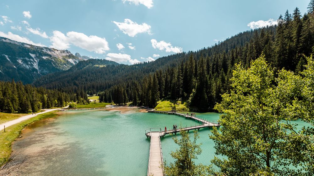
Want to discover the "green diamond of the Alps"? Then the superb Lac de la Rosière and the Cascade des Poux is definitely your next destination! A natural setting at the foot of the Dent du Villard, with its footbridge across the lake.
Lac de la Rosière Car Park
By shuttle bus (line H), go to the end of the line and get off at the “Lac de la Rosière” stop.
By car, turn left at the first roundabout as you come into Courchevel Moriond, take several sharp bends heading towards Belvédère and take “Route de la Rosière” going downhill on the left, on the same level as the hiking symbol, just after Le Zenith hotel.
It can sometimes be difficult to park at La Rosière, so we recommend that you park at the Cimes Blanches (free covered car park in summer) car park in Courchevel Moriond, and take a shuttle bus that will drop you right at the site entrance.
0/ Courchevel Moriond – la Rosière lake car park (1 537 m)
1/ Take the direction of the Rosière lake
2/ After the cabin, cross the bridge
3/ Take the track on the right to the nature trail.
4/ The path climbs through a magnificent pine forest.
5/ Follow the path on the right back to the valley
6/ Once back on the track, go up the valley on the left towards the Cascade des Poux.
7/ You are at the Poux waterfall (1645 m)
8/ The return leg follows the stream to the lake.
Type of itinerary : circuit. Maps : IGN Top 25 n° 3534 OT Les Trois Vallées.
Services
Rates
Gratuit
Period(s) of use
From 15/04 to 31/10
Home
Pets allowed
1/12

Things to discover nearby
Explore our hikes

Pedestrian sports
Petit Mont Blanc
Courchevel
20.2km
Level red – hard
970m
970m
Enjoy 360° panoramic views from the Vanoise glaciers to Mont Blanc. The peak takes its name from its rounded shape, similar to that of its big brother, and the gypsum that looks like snow.

Pedestrian sports
Lacs Merlet - Col de Chanrouge
Courchevel
16.7km
Level red – hard
810m
810m
Extend your walk for a view out over a third lake, the Lac du Pêtre. From the mountain pass, enjoy unrivalled views of the Courchevel valley, the La Plagne ski area and the Mont Blanc mountain range.

Pedestrian sports
24 - Sandraz - Bois du Ban (été)
Courchevel
3.4km
Walkers/hikers
90m
140m
This path takes you to Kamelot Camp amongst the fir trees, where you can refuel at the little Canadian-style cabin and sample fun, original activities at the lake.


